
![]() Geospike – the Social Travel Journal
Geospike – the Social Travel Journal
Geospike is a free app for iOS and Android devices, while upgrading to Geospike PRO will cost just €5.99. There is a supporting online platform and website at www.geospike.com, from which you can sign up for a monthly newsletter and join an online community of users. The app allows instant recording of a data ‘spike’ of your location in the field (using the internal GPS of the mobile device) to which you can attach photos, videos & field notes. The Geospike app works offline to allow data capture anywhere in the field and automatically records location, time and date. Creating a user profile enables you to access your data within the app and/or online and produce a log of all of your field sites across the world. There is a range of base maps enabling you to create annotated maps and galleries of your travels. You can export your data or share your field log with others using email or social media.
For a quick demo of how to use the app, watch this 1.06min YouTube video
![]() The Enhancing Fieldwork Learning Team
The Enhancing Fieldwork Learning Team
 We are a group of academics working together to promote fieldwork in Higher Education curricula and researching ways to enhance field learning through the use of mobile technologies.
*Derek France, Katharine Welsh & Vicky Powell (University of Chester, UK)
*Julian Park & Alice Mauchline (University of Reading, UK)
*Brian Whalley (University of Sheffield, UK)
We have used Geospike to log our field sites in Iceland with Final year undergraduates from the University of Reading, UK and the University of Akureyri, Iceland on a joint Microbiology field-based module led by Dr Rob Jackson.
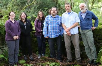
(L to R: Vicky, Katharine, Alice, Derek, Julian, Brian)¦ Website: www.enhancingfieldwork.org.uk ¦ Twitter: @fieldwork_ntf
 Case Study of the use of Geospike in field teaching
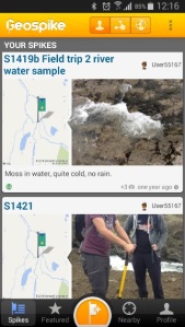
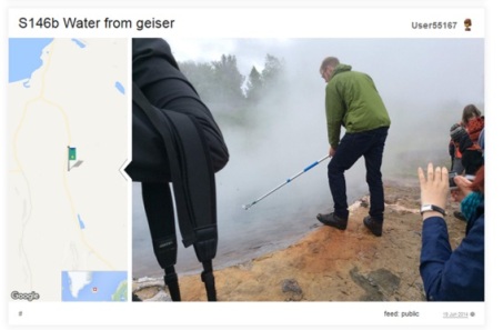
Fig 1. Example data ‘spikes’ of sampling techniques and field sites
Microbiology students are often provided with microbial samples to work with in the lab without a real appreciation of the environment from which it was taken. Rob Jackson developed a field-based module to provide final year students with an environmental understanding of microbial extremophiles and to develop the students’ field sampling skills (read more at http://tinyurl.com/pvkgac2). We provided a class set of iPads to support and engage the students in their learning on the fieldcourse and to facilitate communication between the students and staff in the large multi-national team.The students were asked to log into a group Geospike account and use the app to record the exact location of each of their field sampling sites and take field notes to record the environmental conditions (e.g. weather conditions, physical details of the site, habitat type). They were also asked to attach representative photos of the local environment and of any specific field methods employed (Fig 1.).
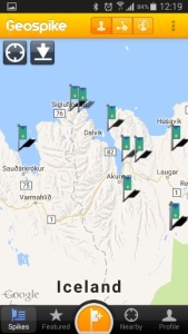
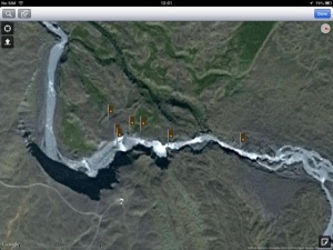
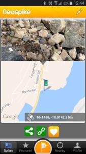
Fig. 2. Examples of maps at different spatial scales created using Geospike
After the field excursions, students were then asked to log in to the group GeoSpike account to produce maps at suitable scales for their presentations and reports (Fig. 2). The shared Geospike log provided the student group with a permanent record of the field location and environmental conditions from which their microbial samples were taken. The student group then conducted several laboratory-based experiments using a variety of the field samples and were able to refer to the Geospike database for records of the field locations.
Benefits
- Geospike provided the group with an efficient and accurate way to capture, store, share and display location data during fieldwork.
- This approach enabled the student groups to co-create a novel dataset of potentially important microbial extremophile samples with a visual and geo-tagged record of the field sampling techniques.
- It ensured that the students made the conceptual link between the environmental selection pressures they witnessed in the field and the adaptations displayed by the bacteria and viruses they collected.
Student feedback
- “The Geospike Log was very helpful to get the exact location where we took our sample”
- “I was impressed with the GPS and sampling facilities [of the iPad]”
- “Brings together several useful applications in one place… so we don’t need three or four pieces of equipment”
Tips
- Add a clip-on microscope to the iPad to allow the capture of detailed images in the field (e.g. www.olloclip.com)
- Consider using a group Geospike account to easily collate student field data.
- Work offline in the field using mobile devices to avoid the need for internet connection (however, wi-fi-only tablet devices do not have such GPS capability).
- Use this app can be used to build up a long term data repository as successive trips visit the same area.
Summary
Please contact Alice Mauchline (a.l.mauchline@reading.ac.uk) or Derek France (d.france@chester.ac.uk) if you wish to find out more about using Geospike in field teaching or about the Enhancing Fieldwork Learning Project.
 Further reading and resources are available:
- Case study 7: iPads as digital Field Notebooks in Microbiology Fieldwork (Alice Mauchline and Rob Jackson) in: France, D., Whalley, W. B., Mauchline, A., Powell, V., Welsh, K., Lerczak, A., Park, J. and Bednarz, R. (2015) Enhancing fieldwork learning using mobile technologies. Springer Briefs in Ecology. Springer, Cham, pp 173. ISBN 9783319209661
- Welsh, K. E., Mauchline, A., Powell, V., France, D., Park, J. R. and Whalley, W. B. (2015) Student perceptions of iPads as mobile learning devices for fieldwork. Journal of Geography in Higher Education, 39 (3). pp. 450-469.
- France, D., Whalley, B. and Mauchline, A. (2013) Using mobile devices to enhance undergraduate field research. CUR Quarterly, 34 (2). pp. 38-42.
- Welsh, K. E., Mauchline, A. L., Park, J. R., Whalley, W. B. and France, D. (2013) Enhancing fieldwork learning with technology: practitioner’s perspectives. Journal of Geography in Higher Education, 37 (3). pp. 399-415.
- www.enhancingfieldwork.org.uk
![]() Either tweet using #12appsDIT and @fieldwork_ntf, and/or post in the comments section at the bottom of the page, to share your thoughts on how you might use Geospike in your teaching.
Either tweet using #12appsDIT and @fieldwork_ntf, and/or post in the comments section at the bottom of the page, to share your thoughts on how you might use Geospike in your teaching.
 Optional Task…
Have a go at using Geospike! Create a username and password at www.geospike.com and go outside…. Make a ‘spike’, add a photograph of something of interest and then share it on Twitter using the hashtag #12appsDIT and @fieldwork_ntf.


Just completed an Educational/Research trip to India looking at their Emergency Medical Services. This would have been perfect for documenting the trip. Hope to go back soon and this is an absolute must
LikeLiked by 2 people
I believe the EFL team who wrote this case study also use the app GPS Log and they’ve written an article about using both apps and the development of graduate attributes in the Journal of Geography in Higher Education (Vol 40 No 2). Alice or Derek, whose contact details are given above, would be able to tell you more. I’m delighted this case study has been of inspiration already 🙂
LikeLiked by 2 people
We would be very happy to discuss the use of Geospike and GPS Log for capturing data in the field – we have found both apps very easy to use with students and they provide a great reference for reflection.
LikeLiked by 1 person
I go to Australia every year for 6 weeks. This would be perfect for me for bird and wildflower identification. However, my US phone does not work in Australia or overseas, since US phones are crippled do not allow swapping SIM cards. I see the team went from the UK to Iceland, what arrangements did they have to make to access the GPS with their phones in Iceland in the field? I do have wifi access on my iPad. Could I take photos in the field and then come back to the local wifi and access the app that way?
LikeLiked by 2 people
I’ll leave Alice or Derek to answer that one – they’ll be online during the day.
Thanks,
Frances
LikeLike
Hi Lucy, We used iPad minis and Google Nexus tablets in the field to record the data within the Geospike app while we were on fieldwork in Iceland. These tablets were 3G enabled but didn’t have a SIM card in them – this meant that we were working offline in the field, but the devices were still capable of recording their location in the field. When back on the University wifi we could access the base maps and our ‘spikes’ appeared in the correct locations. Does your iPad have 3G capability (even if there is no SIM card in it)? Also, your phone might still be able to record the data in the field with the ‘mobile data’ switched off too – let me know if you have any success. Alice
LikeLiked by 1 person
thanks for the info. very helpful
LikeLike
Good app to put into use during field trips- efficient accurate way to store share display
LikeLiked by 2 people
Great first app, perfect for fieldwork
LikeLiked by 2 people
I’m not involved in field work but it looks like quite a useful app for such purposes.
LikeLiked by 2 people
Not quite sure how to apply it yet (other than for holidays)….possibly could be used as part of a student’s work experience journal….
LikeLiked by 1 person
A work experience journal is a great idea. It can help to take you back to locations to remember the activities and learning opportunities. Can share with others too.
LikeLike
It sounds like a good app for fieldwork which facilitates discussion and promotes student engagement.
LikeLiked by 2 people
As a chemistry teacher, I can see this app being very useful when collecting field data for various potential environmental projects.
LikeLiked by 2 people
As a primary teacher I will use it with my 10 years old…it’s a good visual tool that can help for location and recording
LikeLiked by 2 people
Great app to research places
LikeLiked by 1 person
Looks like a great app and it would have been nice to see how the app works in a little bit more detail-ie how top place the maps with the flags placed alongside the images.
We have a Garden Design course at our college who have many field trips throughout the year so I think this would be a great app for them to log and share information.
LikeLiked by 2 people
The case study is just to get your started really – to make you aware of the app, give you some ideas, and provide some links that you can explore further. We were conscious of not making the pages each day too long and detailed or we’d break our ’10 minutes a day’ promise 🙂
LikeLiked by 1 person
It is very straightforward – I’m sure that your students will find it intuitive to use. Good luck!
LikeLiked by 1 person
Fascinating. Being able to create maps at different spatial scales looks particularly useful.
LikeLiked by 2 people
I think this would be a very useful app for our science department, especially when collecting information from the same area and studying climate, erosion, plant life, biology, etc.
LikeLiked by 2 people
Perfect!
LikeLike
This is a fabulous ‘first app’ to get the wheel’s turning. Nicely done!
LikeLiked by 2 people
I’m not involved with field work, but this looks like an interesting app for those who are.
LikeLiked by 2 people
It has applications way beyond fieldwork though. I really like the idea above about using it as part of a student work experience journal.
LikeLiked by 1 person
Keep getting a “Problem Connecting to the Server” error on my iPhone. I have both Wifi and Data
LikeLiked by 1 person
Also cannot login to heir website on my desktop. Looks like they are having problems
LikeLiked by 1 person
I haven’t been able to create an account via the browser today either. Has #12appsDIT bombarded their site?! 🙂
LikeLiked by 1 person
I like the concept, but after multiple failed attempts to get the app to work on my iPhone, I ended up deleting it. I found a similar app called LiveTrekker on the App Store that’s definitely worth a look. Wayne.
LikeLiked by 2 people
Thanks a million for sharing LiveTrekker here Wayne. If anyone comes across others, please post here.
LikeLiked by 1 person
It looks good, and it lets you add video and audio to the recording too.
LikeLiked by 1 person
Thanks Wayne – yes that looks like a great alternative app. It too has the useful function of allowing you to share your journeys.
LikeLike
Oh dear…yes it does look like all the excitement of #12appsDIT might have crashed their server! Let’s hope they can rectify the problem asap!
LikeLike
Looks all the interest from the 12apps community resulted in the Geospike server to become non responsive. Geospike.com server is back up and running.
LikeLike
I’ve been mulling over experiential education and the use of reflection as part of the learning experience, so I’m particularly intrigued by this app and its potential for supporting the reflective cycle. I’m curious as to how this might be a way to help students contextualize and define the “concrete experience” stage of Kolb’s cycle, where they are receiving some additional direction and support for organizing their experience in the field and making decisions on what information they are collecting to reflect on later. I recognize the academic/practical utility of the app as well, but can see opportunities for scaffolding the reflective experience right from the beginning. Has there been any work done in using data collected from the app to not only conduct experiments but reflect on the field experience itself?
LikeLiked by 2 people
Great post Lisa – thank you. I’ll leave it to Alice to reply later to your question at the end there.
LikeLike
Hi Lisa, Thanks for your thoughts. We were also interested in how this kind of approach could be used to help students reflect on their learning experiences in the field. In a subsequent field trip we used the Geospike app along with several others to collect and share data. This was supported by the use of a private group in Facebook as a communication channel for staff and students to interact and share thoughts. We encouraged everyone to participate in this exercise and scaffolded the interactions to gradually prepare the students to write a reflective blog post that was publically available. You can read more about this here: http://blogs.reading.ac.uk/engage-in-teaching-and-learning/2014/08/27/facebook-ipads-and-extreme-microbes-in-iceland-by-dr-becky-thomas-dr-alice-mauchline-and-dr-rob-jackson/ I think that the data collected in Geospike was of immense importance when writing this reflective account to help ‘take them back to the field’.
LikeLike
Hello! Thank you for your response and insight. The private Facebook groups sounds like a great way to engage students in reflective dialogue. Reading the blog you provided, I can also see a great benefit to using the group as a way to prepare students for the field experience, including pointing them to key information and ideas to have top of mind during their time in the field. I will say I’m particularly impressed with using blog posts as a means of reflection as well as assessment – what a great way to combine learning and evaluation. 🙂
LikeLike
I’m not directly involved with students who do fieldwork through my position at work, so I can’t comment on the app as a tool for this. But as I’m based in London, I can see how this could be used as a social media tool for students to share knowledge about the campus and its surroundings, perhaps tagging their favourite coffee shops or unofficial places to study. Getting to know a big city can be daunting for new students, so having peer-driven tips could be a nice way to explore.
LikeLiked by 2 people
That’s a great use for it. Could be part of the induction process.
LikeLike
Nice idea. I like your thoughts on peer support.
LikeLike
This is an interesting app- I’m thinking of how I will use it in the future. I will encourage our science teachers to consider using it when they travel to a local zoo for field work.
LikeLiked by 2 people
Great start! Combining notes, location and photos in one ‘space’ is really good as no fear of missing anything out! Very useful for fieldwork but will continue to read the comments to see how colleagues plan to broaden scope of its use.
LikeLiked by 2 people
Will suss how if I could use this during Orienteering in PE class!
LikeLiked by 2 people
fantastic!
LikeLike
A great introduction to the idea of how apps can be integraged into learning. I am delighted to have the opportunity of gaining more insights into such innovative practice.
LikeLiked by 2 people
I work with Blind and Visually Impaired children. I think that this could be a very useful app when working on orientation and Mobility skills for my students to be able to map locations of where they are going and/or where they have been and then to be able to retrace those steps. This could potentially be an awesome tool for a freshman at college learning their way to new classes and around campus. The possibilities are endless. Very interesting!
LikeLiked by 2 people
There are quite a few other mapping apps and tools available. We will publish a blog post on our website in the next couple of weeks with some more suggestions. We would love to hear any more ideas of how this could be used – such a great variety of applications!
LikeLike
Thanks, very interesting first post. We’ve got a 1st year mixed research methods intro module and have been thinking of how student projects could bring in location based element to apply GIS they are taught in labs. Maybe Geospike would be just the job for some ground truthing work?
LikeLiked by 1 person
That would make a very interesting study. Do keep us informed if you take this forward.
LikeLike
Seems useful for high school science field trips as well as for interdisciplinary work that includes information on the context of the topic through photos and videos.
LikeLiked by 2 people
This app looks great and I can already see some teaching areas where it would be particularly valuable. I’ll be sure to pass it on to colleagues.
LikeLiked by 2 people
Interesting app. I wonder if this could work (perhaps in conjunction with another app) so that someone visiting, or researching, a specific site or location could find out what other Geospiked photos, writing, research etc. are associated with GPS? Imagine visiting a ruined castle somewhere… not one famous enough to be in guidebooks, websites etc. — but entering the GPS you can find poems, photographs taken in various seasons, flora and fauna, historical research, etc. Maybe something already allows this and I’m just behind the curve. But with today’s technology, we’re always behind the curve…
LikeLiked by 2 people
Great question – anyone know of anything like that that’s been done before?
LikeLike
What a great idea. I know that Google maps are trying to crowdsource images for different locations. There are lots of citizen science intitatives such as https://www.recordtheearth.org/index.php that are collating soundscapes and other types of media across the globe. I’m sure there are many others collecting individual types of data, but I don’t know of an overarching one that brings them ALL into one place…
LikeLiked by 1 person
I’m a high school teacher and I like this app because it could be a support in the study of many subjects such as geography, study of foreign cultures, chemistry and many other subjects. It can give the knowledge on the field that the study in a class cannot provide.
LikeLiked by 2 people
Great app and so simply to use and demonstrate. I agree with Lucy, this is a great way to add reflections and context to events and experiences. It could also encourage students to use photos to evidence their experiences also! Thanks Frances, great start!
LikeLiked by 2 people
I love the idea and the results look great, but after doing a little research I don’t think I could recommend Geospike. The app is free, yet I was asked for financial confirmation when I installed it. There was a warning about password security when I logged in from a desktop. I wonder if there is “anybody home”; it has been two years since the software was updated or there was any activity on Geospike’s blog, Facebook page, or Twitter feed. The app gets mediocre reviews on Google Play and there’s little response on the Apple Store. Not to mention the fact that the servers were funky today, making it impossible to log in for hours.
LikeLiked by 2 people
All good points Chris. As well as showcasing different apps, the purpose of this short course/CPD opportunity is to get people thinking about how different types of mobile apps could be used effectively and creatively in the educational context. I see that you like the idea of Geospike and the kinds of results they give, so while you may have reservations about this app itself it may spark some ideas and get you looking at better alternatives. If anyone reading these posts has suggestions for alternative apps, please post them here or tweet to #12appsDIT.
LikeLiked by 1 person
Absolutely right about showcasing the strategy. I’d love to hear about up-to-date apps that would support this kind of activity.
LikeLiked by 1 person
It is such a shame that the Geospike servers couldn’t cope with all the interest yesterday! The website is working again today and I hope that you are able to see the value in the approach. As mentioned above, we plan to write a blog post on the http://www.enhancingfieldwork.org.uk website in the next few weeks reflecting on all the useful and creative feedback we’ve got on the case study and the new applications for teaching and learning.
LikeLiked by 1 person
That’s a great way to round up all the thoughts expressed here and on Twitter about your case study. Looking forward to reading it. Please post a link here and at #12appsDIT.
LikeLiked by 1 person
Looks like a very useful app for use in any field work that students would be doing, great for geography or science field trips.
LikeLiked by 2 people
I work mostly with elementary students in the Houston, TX area. Each year our 4th graders take a field trip to Austin, TX. Perhaps this app could be used to capture pictures of the places they visit during their trip. They can journal about what they saw, discovered, and learned.
LikeLiked by 2 people
I will try this out with my Anatomy students working on collecting mosquito eggs in the field.
LikeLiked by 2 people
An interesting app – has a lot of potential re. gathering & collating student field data and to log field-trip learning experiences/reflective activities.
LikeLiked by 2 people
I think this app could be great for study abroad programs, as a way for students to document the different experiences they have in the places that they study.
LikeLiked by 2 people
This would be great for students to catalogue experiences throughout the year to prepare for writing a personal narrative. My students often feel like nothing interesting happens to them, but this might help them record a memory they otherwise would have forgotten.
LikeLiked by 2 people
I really like the Benefits, Feedback, Tips section; it’s very helpful. Will all articles have this?
LikeLiked by 2 people
Most of the case studies have followed the same kind of structure.
LikeLiked by 1 person
Working as an “Information Officer” (Librarian) in a tertiary college I teach research and information management skills to our students. As we have a relatively large number of EAL students learning or improving their English I can envisage this app as being useful to them as they learn their way around a new location – mapping where services and stores are within their new city or town. It could also be very useful to our horticulture students whenever they are on field trips to map the locations of particular plant species.
LikeLiked by 2 people
I’m currently volunteering with the Royal Society of Antiquaries creating metadata for photographs of various monuments around Ireland. Locationwise, I try and get the latitude and longitude for each one but sometimes the closest I can get is the monument’s townland. This app would greatly facilitate the gathering of more accurate location data.
LikeLiked by 2 people
As high school students enter their fields of study, they are going to need to know how to build from their colleagues data findings. I like that this app. allows for the option of group Geospike accounts to allow students (and teachers) to collaborate and build from each other’s findings outside of the classroom.
LikeLiked by 2 people
I believe this app has many useful applications to the K-12 environment. 1) can be used during field trips to record findings. 2) can be used as a visual journal when students take vacations during the school year. 3) Can be used during breaks/vacations to to build rapport with staff, students and families. These ideas are just scratching the surface. Lots of possibilities.
LikeLiked by 2 people
I can see this app would simplify the fieldwork of our TAFE horticulture students identifying and logging the locations of our beautiful but sadly often endangered native fauna here in Western Australia. They currently use a rage of devices including those we nickname trimbles.
LikeLiked by 2 people
This is cool. I could see it really fitting into the Geography field trip work maybe? And Ag Science or Science itself. Love the idea above of it being used on school trips away no matter what the function of the trip. Also keeping parents in the loop if there was a group Geospike.
LikeLiked by 2 people
As an English teacher, I am thinking about how I could use this. When I teach adjectives, I like to get my students outside and get them describing certain objects. I could assign for homework the use of this app, asking them to locate an object outside, attach an image of the object and then write a paragraph describing the location.
LikeLiked by 2 people
This would be a great app for world language students participating in an abroad experience, writing a journal on their experiences and physically mapping their locations linked to their notes.
LikeLiked by 2 people
As a high school HPE teacher, I can see myself using this app to make Orienteering so much more interactive for the students. Having a group account I can make sure they are hitting the right co-ordinates as their GPS location is recorded, and activities can include taking photos at the location or check-points. I’m excited to try this out…
LikeLiked by 2 people
Not just that I like the app, but I ‘m very glad, that examle is from the university level. Too often is tought (at least in our country) that mobile learning is just for playing and not for serious work. Great work and thank you for the idea. I will definitly use it with my secondary school students at history.
LikeLiked by 2 people
Looks like a great app to use for all kinds of purposes
LikeLiked by 2 people
This app will be a great teaching tool for my High School Geography students. It’s hard to get students to understand the concept of place and Human-Interactions in Geography.. With this app, students can see the connection between the effects of humans on environment and a specific location.
LikeLiked by 2 people
This app could be a great tool for media students to assist in location scouting. All photographs and practical information about the location could be recorded and retrieved as required.
LikeLiked by 2 people
Looks like a great app however not relevant to my subjects.
LikeLiked by 1 person
This is a great app for field trips. Thanks for sharing this tool.
LikeLiked by 2 people
I work in the field of social care and could see the relevance of this for engaging students with issues about social inequalities
LikeLiked by 2 people
I really like this app and can see lots of potential for use in field studies. I wondered can you use ‘street view’ display as well as maps (as in google maps). I also wondered if you can store the data and access it later? I imagine you must be able to do so. It would be so useful for return visits to sites to study change over time. Thanks very much.
LikeLiked by 2 people
Not sure about FB linkage for second level. Nice but I think there are other ways around it if you really want to do something like this.
LikeLiked by 2 people
Interesting looking app. I teach and do research in the area of healthcare and ageing. I am thinking about possible uses for this app for learner activities around exploring the age-friendliness of local communities, especially given our focus on promoting age-friendly societies to support people living at home for longer as we age. Thanks.
LikeLiked by 1 person
It’s really interesting. It can help also when you visit a place and you find something students can learn from it, so they don’t have the possibility to go you can share real and own information based on your perspective as teacher. and what you really want students do.
LikeLiked by 1 person